Miami, FL – Gridics LLC announced an agreement with New York City’s Department of Planning to pilot its 3D zoning and planning software platform. Under the terms of the pilot, the department’s urban design and technical review teams will use Gridics’ proprietary zoning engine to more quickly test and visualize both site-specific development allowances and proposed ordinance changes.
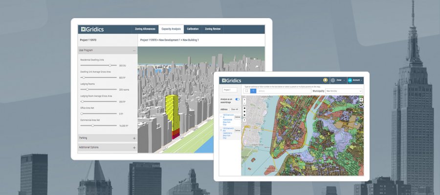
Today’s announcement is another example of how the Gridics suite of products is changing the way users acquire and interact with zoning data. The platform’s patent-pending GIS and zoning rules engine uniquely unlocks the measurable data trapped within traditional text-based zoning codes and its solutions offer users breakthrough functionality. For example, for the first time, users in NYC can now calculate and visualize, in 3D and in real time, how zoning regulations apply to a specific neighborhood, block, lot, or assemblage of lots. Accounting for all zoning parameters and permutations (including competing and overriding layers), Gridics helps users better understand what is currently described in text form at an area level.
“Written zoning regulations play such a crucial role in how our physical communities are developed; yet trying to explain to citizens and elected officials what those words tangibly represent has never been possible in a real-time, point and click manner,” says Max Zabala, Urban Planner and Co-Founder of Gridics. “From an urban design standpoint, city planners armed with our 3D zoning platform are now able to test whether their written code will drive the intended development patterns and outcomes.”
After years of development, Gridics is starting to roll out commercial products that take advantage of its digital zoning code engine. By combining measurable zoning regulations with geo-spatial attributes and property records, Gridics is able to help city staff and real estate professionals calculate and visualize actual site-specific development potential as allowed by zoning. Use-based development analysis has traditionally been a manual and cumbersome process that took an inordinate amount of time and cost thousands of dollars. The Gridics engine turns written zoning values into math allowing for the real-time calculation and visualization of every property’s development potential on a map based interface. The result is a bridge between the public sector and the private development community, communicating in a more efficient processes, with smarter regulations and developing better cities.
Founded in Miami, FL, Gridics secured early adoption of its platform by the Cities of Miami and Fort Lauderdale before announcing the integration of New York City’s zoning code this summer. “New York City has one of the most complex codes out there, so we knew if our technology could account for all its attributes we would be strongly positioned to bring our zoning engine to any city in the world, large or small,” says Jason Doyle, Gridics CEO. “We are thrilled that our platform has been embraced by the NYC Planning Dept and believe this is an early step towards truly improving how cities are planned, understood, and analyzed.”
To learn about the Gridics platform, please visit www.gridics.com or www.zonar.city.
About Gridics: Headquartered in Miami, FL, Gridics is a real estate technology company developing targeted data, analytics and software applications for municipalities and real estate professionals in the areas of planning, zoning, development and commercial real estate.